INTERIORS & EXTERIORS | OUTDOOR TREASURES | SCENIC & HISTORIC MISSISSIPPI | SOUND MIND & SOUND BODY
TALK TO THE ANIMALS | WEBVENTURING | WHATEVER HAPPENED TO...? | SITE MAP | CONTACT US
MISSISSIPPI'S FIRST EZINE

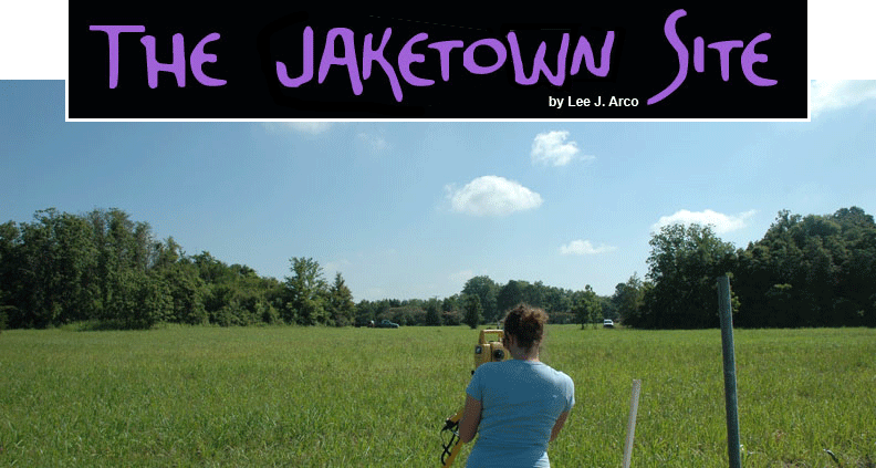
Topographic mapping at the Jaketown site carried out by Samantha Halstead during the 2009 season.
Mound C can be seen at the left and Mound B at the right. Both are Mississippi Period mounds.
Toward the end of the Archaic Period in eastern North America, earthen mound construction, extensive long-distance trade, and technological developments reached unprecedented scales among the hunter-gatherers of the Poverty Point culture. The culture flourished throughout the Lower Mississippi Valley ca. 1800-1000 B.C. and is named after its largest site, the Poverty Point State Historic Site, located in northeast Louisiana.
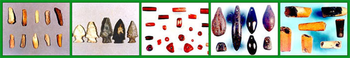
Clay pipes, projectile points, red jasper beads, and plummets unearthed at the Jaketown site.
— photos from the National Historic Landmarks Survey collection
The Jaketown site in west-central Mississippi is the second largest extant Poverty Point settlement, spreading over more than 200 acres in Humphreys County, Mississippi. Although the site is less than half the size of Poverty Point, Jaketown is more than 20 times larger than the next biggest Poverty Point site. In addition to its comparable size, the artifacts from Jaketown are very similar to, and share many stylistic attributes with, those found at Poverty Point. The materials present at Jaketown indicate that the Late Archaic occupants were fully engaged in the vast Poverty Point trade network that included areas in the Ouachita, Ozark, and Appalachian Mountains, as well as regions of the Upper Mississippi Valley and the Great Lakes. In addition to its Poverty Point occupation, Jaketown also has subsequent Woodland (A.D. 600) and Mississippian (after A.D. 1000) occupations, and several mounds and mound remnants from the Poverty Point and Mississippian periods.
During the middle of the 20th century, Jaketown received considerable research interest and extensive excavations were undertaken at the site in 1951. Following the work in 1951, no major archaeological investigations were conducted at Jaketown until 2007, when researchers from Washington University in St. Louis, Missouri began a multiyear project, involving excavation and coring of the site with the objectives of defining the site’s chronology, examining its mound construction history, and analyzing soils/sediments to determine how frequent flooding from the Mississippi River and its tributaries affected Jaketown’s prehistoric inhabitants. The stratigraphy of the site is also being examined to help reconstruct changes in the site’s landscape and environmental setting during different phases of prehistoric human occupation. The most recent of this work was conducted in the summer of 2009, when Washington University and Murray State University in Murray, Kentucky directed a joint field school at the site.
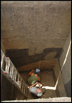
Left: Archaeologists Marina Lizarralde (in the green top) and Nathan Vanausdoll drawing the stratigraphy of an excavation unit
at the Jaketown site in 2009. Note the depth of the dark Poverty Point cultural deposits towards the base of the unit.
Recent studies in northeast Louisiana have identified evidence of catastrophic flooding and large-scale changes in the Mississippi River system between 1000 B.C. and 500 B.C., which have been implicated in the dissolution of the Poverty Point culture approximately 1000 B.C. These events are also believed to be linked to a 500-year gap in occupation within many areas of the Lower Mississippi Valley and to the pronounced cultural differences between the Poverty Point and the succeeding Early Woodland inhabitants of the region.
Evidence of flooding during this interval has also been found at Jaketown, where the earliest Poverty Point occupation has been deeply buried by sediment. In some areas of the site, these archaeological deposits are found as deep as 12 feet below the modern ground surface (see photograph, above left). Through evaluating archaeological and environmental data sets from Jaketown, the current research seeks to examine the regional extent/impact of these flood episodes and provide a more comprehensive and detailed understanding of the degree to which human behavior was influenced and/or structured/constrained by the dynamic Lower Mississippi River. In addition, the work aims to provide a first step toward expanding our regional understanding of Poverty Point society and broadening our insight into this unique hunter-gatherer phenomenon.
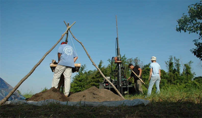
Anthony L. Ortmann (left) screens dirt to recover any small items not immediately apparent while Lee J. Arco, the author,
and Lara K. Homsey (in hat at right) extract a soil core sample.
Tree-covered Mound C can be seen in the background.
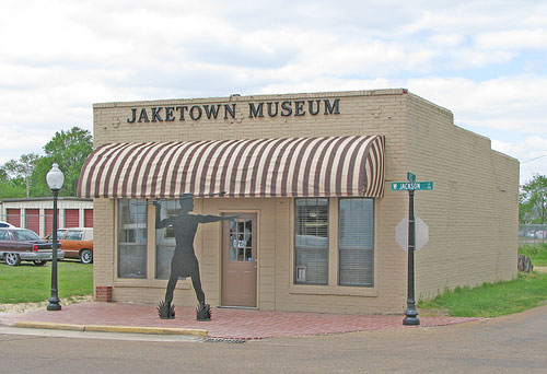
Jaketown is conveniently located along Mississippi Highway 7, approximately four miles north of Belzoni. The site was declared a National Historic Landmark in 1990 and is managed by the state of Mississippi. Various artifacts from the site and surrounding area, dating from 2000 B.C. – A.D. 1400, are featured on display in the Jaketown Museum in Belzoni, Mississippi.
Author's note: The Jaketown site is jointly owned and managed by The Archaeological Conservancy and the Mississippi Department of Archives and History.
COPYRIGHT © 2001-2010 THE NEW SOUTHERN VIEW | 2/17/10
