I grew up in a family of “Rockhounds” and amateur geologists; my parents were among the founding members of the Mississippi Gem & Mineral Society. Therefore, my childhood memories don’t include a day that I “learned about the volcano.” It was always a part of my world, a ghost from the past.
I accepted the fact that I had a volcano underfoot but, for me, the awareness ended there. Growing up with this knowledge, I never thought to question it. Various adult sources placed the throat of the volcano at Fossil Gulch on the Nature Trail in what was then known as Riverside Park, now Lefleur’s Bluff State Park in Jackson. Others adults told me that Millsaps College had the eminence of being located directly over the mouth. But try as I could, I never spotted what remained of the volcano’s cone; there was no indication of danger underfoot. In my childish imagination, I anticipated a cataclysmic eruption. Needless to say, I was disappointed.
This memory receded with age as other more immediate matters took its place. Then, while finding out why the waters of the Alligator Pond at Leroy Percy State Park are a constant 88° F year-round for another article, I was reminded of our hidden volcano. Dr. David Dockery, Director of the Surface Geology Division of the Mississippi Department of Environmental Quality, Office of Geology, mentioned the Jackson gas field that was discovered in the 1930s. This field, he said, tapped “the Jackson Gas Rock...a reef that grew over the old volcano.” The ghost had returned.
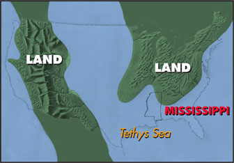
This particular ghost had its beginnings during the late Cretaceous period, a time when much of what is now North America was a series of islands surrounded by shallow seas (see map at left). It was the time of the great dinosaurs: the Titanosauria, the heavily armored Ankylosauria, the horned Certopsia, the sickle-clawed deinonychids, and of course, the Tyrannosaur. And what is now Mississippi was represented by two volcanic islands; one in the southern portion of present day Humphreys County—the Midnight Volcano—and the other, a 420-square mile island, the Jackson Volcano, situated directly under our Capitol City.
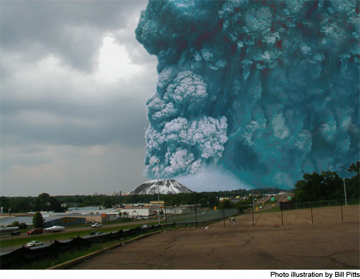
Now rest assured, the Jackson Volcano last erupted about 75 million years ago (determined by analyzing core samples drilled from the dome), 10 million years before the Cretaceous-Tertiary Mass Extinction event in which it is theorized that a 6-mile diameter asteroid struck the earth off the coast of what is now the Yucatan Peninsula leaving a crater over 100-miles wide, called the Chicxulub crater (pronounced Chick-shoo-loob, it’s a Maya word that roughly translates as “tail of the devil”). This event lead to the extinction of about 70% of all life. Although extinct itself, the volcano is here, and it has company.
“The Mississippi River follows what is known as the Mississippi Embayment,” David tells me. “This is a syncline, or a trough-shaped fold in the earth, that stretches from Illinois south to the Gulf of Mexico and beyond. The Jackson Volcano is on the east side of this syncline and the Monroe Uplift, another Cretaceous volcano, is on the west side. They’re kind of symmetrical. Further north is the Murfreesboro, Arkansas Volcano. And then, there’s a buried volcano at the mouth of the Mississippi River called the Door Point Volcano. So there’s a ring of volcanoes around what’s now this slumped syncline. And the New Madrid Fault is part of that over-all feature.”
“And even though it’s buried about half a mile deep below Jackson, we feel the affects of it today: hot water in excess of 100°F, carbon-dioxide gas, hydrogen sulfide gas from an 18,000 foot deep well near Piney Woods measuring 320°F [at the bottom of the well], and the natural gas in the gas rock. But also, apparently—the volcano is still pushing up a little bit.”
Not noticeably so, but enough to be apparent on the surface in the form of the problematic Yazoo Clay, a soil that is a sub-surface feature on either side of the dome. “Even though the volcano is extinct, the core of that volcano has risen, so that it has pushed up the sedimentary rocks that overlay the dome.” And by pushing up on that 400 foot thick layer of clay, it has stretched it wide across the Jackson area. You can blame your foundation problems on our volcano!
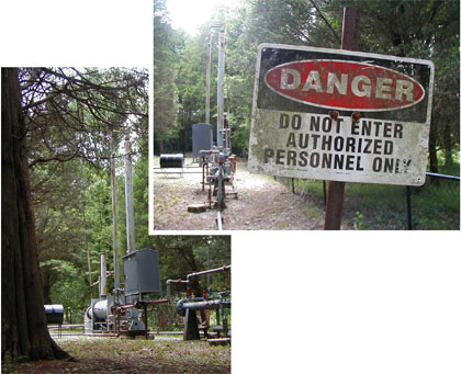
On the Lefleur’s Bluff Golf Course (left), a methane gas well drilled into the Jackson Gas Rock during the 1930s.
David continues, “one-fourth of the nation’s reserve of carbon-dioxide gas is in Hinds, Madison, and Rankin Counties around the Jackson Volcano—in the deep rocks...carbon-dioxide comes from volcanic emissions...the volcano has charged the rocks with carbon-dioxide gas.” Plus, there’s the 102°F water from a 1,600-foot deep well at the Duke Energy Plant just off I-220 in northwest Jackson. “There’s still some heat energy associated with that old volcano.”
So, we do indeed have a volcano, albeit extinct and buried under millions of years of sediment, but it is there just the same. My ghost has been confirmed, and named the Jackson Volcano—and given a definite location, under our Coliseum. And because of this, we Jacksonians can claim the distinction of being the only capitol city in the world situated on top of a volcano.
 This particular ghost had its beginnings during the late Cretaceous period, a time when much of what is now North America was a series of islands surrounded by shallow seas (see map at left). It was the time of the great dinosaurs: the Titanosauria, the heavily armored Ankylosauria, the horned Certopsia, the sickle-clawed deinonychids, and of course, the Tyrannosaur. And what is now Mississippi was represented by two volcanic islands; one in the southern portion of present day Humphreys County—the Midnight Volcano—and the other, a 420-square mile island, the Jackson Volcano, situated directly under our Capitol City.
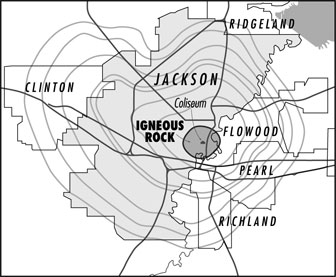
 “Even though the volcano is extinct, the core of that volcano has risen, so that it has pushed up the sedimentary rocks that overlay the dome.” And by pushing up on that 400 foot thick layer of clay, it has stretched it wide across the Jackson area. You can blame your foundation problems on our volcano!